Traumpfad Förstersteig
- start: 56727 Mayen-Kürrenberg, parking lot Am Leichenweg (B 258) (Vulkanpark climbing forest)
- destination: 56727 Mayen-Kürrenberg, parking lot Am Leichenweg (B 258) (Vulkanpark climbing forest)
- difficult
- 16,81 km
- 5 hours 30 minutes
- 509 m
- 525 m
- 265 m
- 80 / 100
- 100 / 100
Fantastic forest paths with breathtaking panoramic views. Halfway along, Bürresheim Castle invites you to visit and offers unique insights into the life of the nobility between the 15th and 20th centuries.
Highlights on the Traumpfad
- Eiterbachtal with pond
- Luisenplatz hut with overwhelming panoramic view
- mighty basalt columns
- Fünfkantstein
- Nettetal
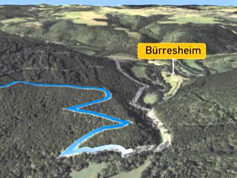
- Bürresheim Castle
- Nitztal
- Scheidkopf with Eifel panorama
Impressions


General information
Directions
The day route on the Traumpfad Förstersteig starts in Mayen-Kürrenberg. From here a forest path leads gently downhill through the shady upland forest via the Ruppental, then through the Eiterbachtal with a lively babbling brook. At the Eiterbach pond, a shelter and benches invite you to linger. Moderately uphill it goes to the Luisenplatz hut with a fine panoramic view over Mayen, the Maifeld, and towards the Rhine. The further hiking trail leads to the shelter Altener Tempelchen with a view of the mighty basalt columns of the quarry opposite. Via paths it goes steadily uphill to the Fünfkantstein (historic waymark, with shelter). Afterwards, the Traumpfad descends and offers wonderful forest hiking. The next highlight is the Nettetal viewpoint, where there is a dreamlike view of Bürresheim Castle and the picturesque Nitztal. Switchbacks lead down into the valley where the Nette is crossed for the first time. At the Hammesmühle, a detour to nearby Bürresheim Castle is worthwhile before the Traumpfad crosses the Nette again and plunges into the forest. Soon follows a short, steep ascent along a rocky ridge. Afterwards, the Traumpfad runs through oak low forest around the Schäalkopf and offers beautiful views into the Nitztal. The ascent continues steadily towards Kürrenberg. Along the forest edge it passes horse paddocks and meadows to the Scheidkopf – the beginning of the concluding panorama festival of the all-day route with wide views over the Eifel landscape!
Safety Guidelines
Surefootedness is required on some passages.
General safety information:
Safety notes - safe hiking on the Traumpfade
Hikers desire narrow paths, nature-close trails (over forest floor, grass paths or along streams) and rocky ascents that lead to spectacular views. It is obvious that such trails must be walked with special care.
What you should keep in mind during your hike:
- Wear weather-appropriate, functional clothing that protects you from cold and moisture or heat and sun.
- Plan your hike with adequate breaks and use your energy sparingly.
- Carry enough fluids. There are not always opportunities to get refreshments.
- Please wear suitable hiking shoes on the Traumpfad that provide sufficient support even on slippery and steep or rocky and uneven paths.
- If you believe that certain trail sections are not passable for you, you should avoid them or turn back. Especially in adverse weather conditions, natural trails can be muddy and slippery.
- In autumn, also be aware that fallen leaves on the ground can conceal unevenness, roots, stones, or holes in the path.
- You have to expect such trail impairments when undertaking a hike.
- Inform yourself before your hike online at https://www.traumpfade.info/traumpfade/wege-status/ whether the Traumpfad you want to hike is possibly closed, if there are detours, if there are planned construction works, e.g., logging or other disturbances.
- Recommended hiking months: April to October.
Difficulty rating:
Easy routes
...have only slight elevation changes and are mostly manageable in half a day regarding distance. They do not require special fitness or surefootedness. There are no trail sections that require a head for heights. Short steeper sections are possible. Depending on the trail type, some parts can be difficult to walk in wet weather.
Medium routes
...are manageable with normal fitness. Path sections may require good surefootedness, so sturdy footwear is important; hiking poles can be useful. Some slightly longer and steeper ascents and descents are possible. Difficult (partially secured) passages are a rare exception and can usually be avoided by detours. Natural sections can be difficult to walk in wet weather.
Difficult routes
...require very good fitness and stamina due to length and/or elevation. Very good surefootedness is needed to master steep ascents and descents on partly demanding paths. Rope-secured sections and/or easy climbing passages requiring a minimum head for heights are possible. Sturdy footwear and hiking poles are important. Paths and exposed sections are often difficult or impossible to walk in wet or wintry weather.
Equipment
Sturdy footwear is recommended for the route!
You can find trail closures at: https://www.traumpfade.info/traumpfade/wege-status/
Tip
Bürresheim Castle awaits your visit.
Getting there
A 48 exit Mayen/Mendig - B 258 towards Nürburgring - behind the Oberst-Hauschild barracks towards Kürrenberg after 700 m turn right into the parking lot located on B 258 (sign: Vulkanpark climbing forest)
56727 Mayen-Kürrenberg, parking lot Am Leichenweg (B 258) (Vulkanpark climbing forest)
Parking
56727 Mayen-Kürrenberg, parking lot Am Leichenweg (B 258) (Vulkanpark climbing forest)
Others: 56727 Mayen, Schützenplatz (At L 83 Bürresheimer Straße) (Access 1.5 km one way)
Public transit
Destination stop: Kürrenberg, Bürgerhaus
Line 380 Kaisersesch - Düngenheim - Kehrig - Mayen - Kürrenberg
Destination stop: Kürrenberg, Hauptstraße
Line 388 Leisure Bus: Mayen - Langenfeld - Arft - Herresbach - Kürrenberg - Mayen (01.04. to 01.11.)
Destination stop: Bürresheim Castle
Line 399 Leisure Bus Vulkanregion Laacher See: Mayen - Rieden - Maria Laach - Nickenich - Andernach - Namedy (01.04. to 01.11.)
Literature
- Traumpfade & Traumpfädchen Volume 2: The 19 best premium circular hikes in the Vordereifel, Ulrike Poller & Wolfgang Todt ISBN: 978-3-934342-61-3
- 27 Premium circular trails Traumpfade, 10-year anniversary edition Traumpfade, Ulrike Poller & Wolfgang Todt, ISBN: 978-3-942779-43-2
Maps
- Osteifel with Laacher-See area hiking map 1:25,000 ISBN: 978-3-921805-63-3
Additional Information
Tourist information of the city of Mayen, Tel.: 02651/903004, touristinfo@mayenzeit.de, https://www.mayen.de/kultur-tourismus/
Project office Traumpfade, Tel.: 0261/108419, info@traumpfade.info, www.traumpfade.info
Traumpfade app
Traumpfade app for iOS: Download app on iTunes
Traumpfade app for Android: Download app on Google Play
Weather


This tour is presented by: Traumpfade im Rhein-Mosel-Eifel-Land, Author: Nicole Pfeifer