Traumpfad Volcano Trail
- start: 56729 Ettringen (Hochsimmerhalle Kottenheimer Straße 31)
- destination: 56729 Ettringen (Hochsimmerhalle Kottenheimer Straße 31)
- medium
- 6,46 km
- 2 hours
- 234 m
- 416 m
- 268 m
- 80 / 100
- 40 / 100
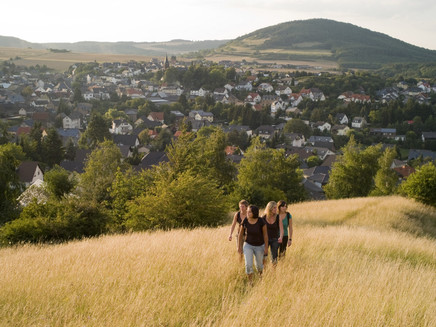
Magnificent views of the volcanoes of the East Eifel, unique insights into the formation history of the fire-spewing mountains - a pleasurable journey into the era of the stone industry.
Highlights on the Traumpfad
Ettringer Bellberg with a dreamlike view of the volcanic landscape
Kottenheimer Winfeld mining landscape
Impressions
General information
Directions
Up close, you can trace the fiery past of the Eifel on the Volcano Trail! This becomes impressively clear right after the start in Ettringen, at the first climb up to the crater rim of the Bellberg, because from above you not only have a great panoramic view towards Mayen but also look deep down into the old crater.
After a short field and forest section, the Traumpfad enters the forest and leads steeply uphill. Soon the crater rim is conquered, and on a magnificent ridge path you hike along the crater with the best views.
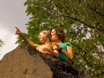
After a steep descent and crossing of the K 20 road, the fantastic passage through the rock labyrinth of the Kottenheimer Winfeld begins, an old mining area where impressive basalt rocks rise, closely passed by the Volcano Trail.
After this concentrated dose of geology, the Volcano Trail leads to the rock monument of Junker Schilling before returning past a mineral spring to Ettringen.
Safety Guidelines
In some sections, surefootedness and a head for heights are required.
General safety instructions:
Safety instructions – Safe hiking on the Traumpfade
Hikers want narrow paths, natural trails (over forest floor, grass paths, or along streams), and rocky climbs that lead to spectacular views. It is of course essential that such paths be walked with special care.
What you should consider during your hike:
- Wear weather-appropriate, functional clothing that protects you from cold and wet or heat and sun.
- Plan your hike with adequate breaks and use your energy sparingly.
- Take enough fluids with you. Refreshment options are not available everywhere.
- Please wear appropriate hiking shoes that give you sufficient support even on slippery and steep or rocky and uneven paths.
- If you think certain path sections are not walkable for you, you should bypass or turn back. Especially in adverse weather conditions, natural paths can be muddy and slippery.
- Particularly in autumn, be aware that leaves on the ground can conceal uneven sections, roots, stones, or holes.
- You must expect such path impairments when hiking.
- Check the internet before your hike at https://www.traumpfade.info/traumpfade/wege-status/ to see if the Traumpfad you want to hike is possibly closed, if there are any detours, if path construction measures are planned, or if there are forestry works or other disruptions.
- Recommended hiking months: April to October.
Difficulty classification
Easy routes
…have only slight elevation differences and can usually be completed within half a day regarding distance. They do not demand special fitness or surefootedness. There are no path sections requiring a head for heights. Short steeper sections are possible. Depending on the path type, some parts can be difficult to walk in wet weather.
Medium routes
…are manageable with normal fitness. Path sections may demand good surefootedness, so sturdy footwear is important; hiking poles can be useful. Some slightly longer and also steeper ascents and descents are possible. Difficult (sometimes secured) passages are very rare and can usually be bypassed. Natural path sections can be difficult to walk in wet weather.
Hard routes
…require very good fitness and endurance due to length and/or altitude meter gain. Also, very good surefootedness is necessary to manage steep ascents and descents on partly challenging paths. Rope-secured sections and/or simple climbing passages requiring a minimum head for heights are possible. Sturdy footwear and hiking poles are important. Paths and exposed sections are often difficult or even impossible to walk in wet or winter weather.
Equipment
Sturdy footwear is recommended for the route!
Tip
Are you curious about the history of basalt mining? Then visit the Erlebniswelten Grubenfeld! From the Volcano Trail, you can conveniently reach the museum via a 1.5 km access path. Interactive stations and exciting exhibits make your visit an unforgettable experience.
Getting there
A 61 exit Mendig - feeder to A 61 exit Kottenheim - straight ahead in the roundabout - next entrance right to Kottenheim - follow the road to Ettringen
56729 Ettringen (Hochsimmerhalle Kottenheimer Straße 31)
Parking
56729 Ettringen (Hochsimmerhalle Kottenheimer Straße 31)
56729 Ettringer Lay (Volcano Park station)
56729 Kottenheim parking lot by the church (Schulstraße) - on school days from 2 pm (access path about 1.5 kilometers)
56727 Mayen parking lot at Volcano Park Erlebniswelten Grubenfeld (An den Mühlsteinen 7) (access path about 2.3 kilometers)
Public transit
Destination stop: Ettringen, Mayener Straße
Line 390 RegioBus: Mayen - St. Johann - Bell - Niedermendig
Destination stop: Kottenheim, train station
RB 38 “Pellenz-Eifel-Bahn” - Kaisersesch-Mayen-Andernach
RB 23 “Lahn-Eifel-Bahn” - Kaisersesch-Mayen-Andernach
Literature
- Traumpfade & Traumpfädchen Volume 2: The 19 Best Premium Circular Hikes in the Vordereifel, Ulrike Poller & Wolfgang Todt ISBN: 978-3-934342-61-3
- 27 Premium Circular Trails Traumpfade, Anniversary Edition 10 Years Traumpfade, Ulrike Poller & Wolfgang Todt, ISBN: 978-3-942779-43-2
Maps
- East Eifel with Laacher See area hiking map 1:25,000 ISBN: 978-3-921805-63-3
Additional Information
Tourism office Vordereifel, Tel.: 02651/800995, tourismus@vordereifel.de www.naturerlebnis-vordereifel.de
Project office Traumpfade, Tel.: 0261/108419, info@traumpfade.info www.traumpfade.info
Traumpfade app
Traumpfade app for iOS: Download app at iTunes
Traumpfade app for Android: Download app at Google Play
Weather

This tour is presented by: Traumpfade im Rhein-Mosel-Eifel-Land, Author: Nicole Pfeifer


