Traumpfad Pyrmonter Felsensteig
- start: 56754 Roes, Pyrmonter Mühle car park (Elztal 1)
- destination: 56754 Roes, Pyrmonter Mühle car park (Elztal 1)
- medium
- 11,44 km
- 4 hours
- 363 m
- 339 m
- 175 m
- 100 / 100
- 40 / 100
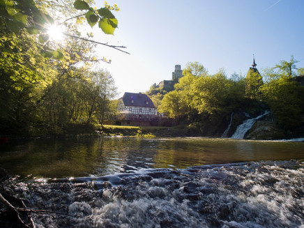
Adventurous paths and steep rock walls alternate with expansive fields and beautiful views. Particularly worth seeing are the medieval Pyrmont castle and the idyllic waterfall at the Pyrmonter Mühle.
Highlights on the Traumpfad
- Pyrmonter Mühle with waterfall
- Sammetzkopf with summit cross
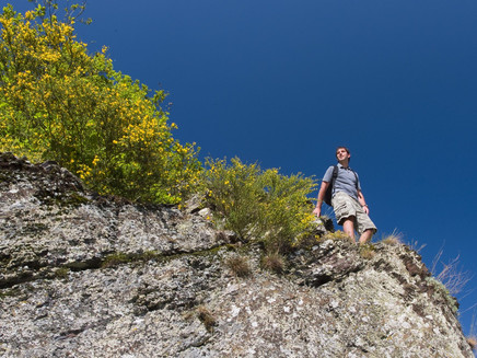
- Rock paths and floodplain landscapes
- Cliffs of the Teufelskammer
- Historic Pyrmont castle
Impressions
General information
Directions
The path starts at the Pyrmonter Mühle car park, near the rushing waterfalls. The path briefly follows the district road until, after crossing it, it leads into a quiet forest trail. Lined with magnificent broom and hedges, a soft grass path leads to a small woodland before winding through extensive fields. Soon, the tall cross on the Sammetzkopf appears, surrounded in spring by yellow blooming rapeseed fields. From there, hikers are offered a fantastic panoramic view of the region. A soft field path leads to the nearby nature reserve at Juckelberg, which harbors true natural treasures such as gnarled forests and splendid blooming broom hedges.
A short rest can be taken at the Hauer hut before the path alternates between up and down, offering wonderful views again and again until finally reaching the Elzbach. The trail follows every bend of the river through a magnificent alder forest and passes the impressive cliffs of the Teufelskammer. From the natural idyll of the Elz Valley, the path is not far from the medieval Pyrmont castle. It continues along a beautiful path into the "realm of rocks" with ivy-covered caves and steep cliffs. After that comes the descent to the Elz valley with fabulous views of the castle. Via a valley path, the Pyrmonter Mühle is finally reached again, where the circular route ends.
Safety Guidelines
+++Surefootedness is required in some sections. The path should not be hiked on ice.+++
+++Flood risk after heavy rain from December to March+++
General safety instructions:
Safety instructions - Safe hiking on the Traumpfade
Hikers want narrow paths, natural trails (over forest floor, grass paths or along streams) and rocky climbs that lead to spectacular views. It goes without saying that such paths must be taken with special attention.
What you should consider on your hike:
- Wear weather-appropriate, functional clothing that protects you from cold and wet or heat and sun.
- Plan your hike with adequate breaks and use your strength sparingly.
- Take sufficient fluids with you. There are not always places to refresh along the way.
- Please wear appropriate hiking shoes for the Traumpfad that provide enough grip even on slippery and steep or rocky and uneven paths.
- If you think certain path sections are impassable for you, you should avoid or turn back. Especially in adverse weather conditions, natural paths can have muddy and slippery sections.
- Especially in autumn, be aware that fallen leaves can conceal unevenness, roots, stones or holes in the path.
- You have to expect such path impairments when hiking.
- Before your hike, check online at https://www.traumpfade.info/traumpfade/wege-status/ if the Traumpfad you want to hike is possibly closed, if detours exist, if trail works are planned or if logging or other disturbances occur.
- Recommended hiking months: April to October.
Difficulty classification
Easy routes
...have only slight elevation changes and regarding distance, can mostly be managed in half a day. They place no special demands on fitness and surefootedness. There are no sections requiring a head for heights. Shorter steeper sections are possible. Depending on the path type, some parts can be difficult to walk in wet weather.
Medium routes
...can be managed well with normal fitness. Path sections may require good surefootedness, so sturdy footwear is important, hiking sticks may be useful. Some slightly longer and steeper ascents and descents are possible. Difficult (partly secured) sections are the absolute exception and can usually be avoided by detours. Natural sections can be difficult to walk in wet weather.
Difficult routes
...require very good fitness and endurance due to length and/or elevation. Very good surefootedness is also necessary to master steep ascents and descents on partly demanding paths. Rope-secured sections and/or simple climbing passages requiring a minimum head for heights are possible. Sturdy footwear and hiking poles are important. Paths and exposed sections are often difficult or impossible to walk in wet or wintery weather.
Equipment
Sturdy footwear is recommended for the route!
Find trail closures at: https://www.traumpfade.info/traumpfade/wege-status/
Getting there
A 48 exit Kaifenheim, L 109 towards Burg Pyrmont to Roes, K 27 towards Burg Pyrmont to Pyrmonter Mühle
56754 Roes, Pyrmonter Mühle car park (Elztal 1)
Parking
56754 Roes, Pyrmonter Mühle car park (Elztal 1)
Access: 56754 Roes, Brückenmühle car park
Access: 56754 Roes, Burg Pyrmont
The parking situation at Pyrmonter Mühle is quite tight due to the great success of the Traumpfade. Please park your car at the Burg Pyrmont car park. You can easily start on the Traumpfad there. Location: 56754 Roes, Burg Pyrmont
Public transit
Destination stop: Pyrmonter Mühle
Line 355 Leisure Bus: Münstermaifeld – Burg Pyrmont – Roes – Pillig – Polch (April 1 to November 1)
Literature
- Traumpfade & Traumpfädchen Vol. 1: The 18 best premium circular hikes on the Rhine and Mosel, Ulrike Poller & Wolfgang Todt ISBN: 978-3-942779-64-7
- 27 premium circular routes Traumpfade, anniversary edition 10 years Traumpfade, Ulrike Poller & Wolfgang Todt, ISBN: 978-3-942779-43-2
Maps
Mosel leisure map "Maifeld and Lower Mosel" (1:25,000), ISBN: 978-3-944620-16-9
Additional Information
Tourist information Maifeld, Tel.: 02605/9615026, touristik@maifeld.de https://www.maifeld.de/tourismus-kultur/
Traumpfade project office, Tel.: 0261/108419, info@traumpfade.info, www.traumpfade.info
Traumpfade app
Traumpfade app for iOS: Download app at iTunes
Traumpfade app for Android: Download app at Google Play
Weather

This tour is presented by: Traumpfade im Rhein-Mosel-Eifel-Land, Author: Nicole Pfeifer


