Traumpfad Heidehimmel Volkesfeld
- start: 56745 Volkesfeld, L 83, Hiking parking lot “Nettetal” Heilquelle Volkesfeld
- destination: 56745 Volkesfeld, L 83, Hiking parking lot “Nettetal” Heilquelle Volkesfeld
- medium
- 9,28 km
- 3 hours
- 310 m
- 528 m
- 344 m
- 100 / 100
- 40 / 100
Lush blooming meadows, spicy-scented heaths, quiet forests, and overwhelming panoramic views enchant the hiker. Rustic huts invite you to rest; the "Sauerbrunnen" healing spring provides refreshment.
Highlights on the Traumpfad
- Volkesfeld juniper heaths with Riethelkreuz
- Primitive Waberner Heide with hut
- Falkleyblick
- Florianshütte with beautiful Nettetal view
- "Sauerbrunnen" healing spring
- Panoramic views
Impressions


General information
Directions
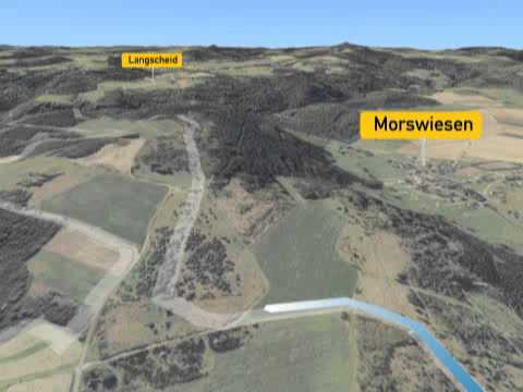
The path begins at the parking lot at the "Sauerbrunnen" healing spring on the L 83 in Nettetal. An access path leads to the starting point at the "Sauerbrunnen" healing spring. Rustic wooden steps and a soft forest path open up the first view into Nettetal and continue on to Volkesfeld. There, the ascent to the impressive and widely visible Riethelkreuz with its fabulous panoramic view begins – nestled in spicy juniper heath. The path leisurely follows the ridge and passes the nearby new development area in a wide arc on meadow paths that lead around the village. After a short forest section and open meadows, another wonderful panorama opens up at the crossing of the K 63. Leaving Volkesfeld behind, the path leads over a soft field path to a resting place.
Soon a narrow trail climbs the height of the Waberner Heide and presents pristine juniper, bright broom, and gnarled pines. With the best view in almost all directions, the Waberner Wacholderhütte invites you to linger. Continuing through the heath, the path changes into the forest to the rock spur Falkleyblick with a unique view into the low-lying Nettetal. On the following forest and meadow sections, wild Cameroon sheep can be observed with a bit of luck. A short detour (a total of 500 m) leads to the Noorkopf with a 270° view. Back on the path, it leads downward along the edge of the field to the Florianshütte with a beautiful view of Nettetal. In the forest, it descends in wide loops into the valley. At the end of the route, the iron-rich water of the "Sauerbrunnen" healing spring invites you to a healthy refreshment before the path ends at the hiking parking lot.
Safety Guidelines
Safety notes - Safe hiking on the Traumpfade
Hikers desire narrow paths, natural trails (over forest floor, grass paths or along streams) and rocky ascents leading to spectacular views. Naturally, such paths must be walked with special caution.
What you should observe on your hike:
- Wear weather-appropriate, practical clothing that protects you from cold and wetness or heat and sun.
- Plan your hike with appropriate breaks and conserve your energy.
- Take enough fluids with you. There are not always refreshment options available.
- Please wear suitable hiking shoes for the Traumpfade, which provide sufficient support even on slippery and steep or rocky and uneven paths.
- If you consider certain sections impassable, you should bypass or turn back. Especially under adverse weather conditions, natural paths can become muddy and slippery.
- Particularly in autumn, be aware that fallen leaves can hide unevenness, roots, stones, or holes on the path.
- You must expect such trail impairments when hiking.
- Inform yourself before your hike on the internet at https://www.traumpfade.info/traumpfade/wege-status/ whether the Traumpfad you intend to hike might be closed, if detours exist, if trail construction measures are planned, or if logging work or other disturbances are underway.
- Recommended hiking months: April to October.
Difficulty classification
Easy routes
... have only minor elevation changes and are mostly manageable within half a day in terms of distance. They do not place special demands on fitness and surefootedness. There are no sections requiring a head for heights. Short steeper sections are possible. Depending on the path format, some parts may be difficult to walk when wet.
Intermediate routes
... are manageable with normal fitness. Trail sections may require good surefootedness, so sturdy footwear is important; hiking poles can be useful. Some somewhat longer and steeper ascents and descents are possible. Difficult (sometimes secured) passages are the absolute exception and can generally be avoided by detours. Natural sections can be difficult to walk when wet.
Difficult routes
... require very good fitness and endurance due to length and/or altitude to be mastered. Very good surefootedness is also necessary to manage steep ascents and descents on sometimes demanding paths. Rope-secured sections and/or simple climbing passages requiring a minimum level of surefootedness are possible. Sturdy footwear and hiking poles are important. Paths and exposed sections are often difficult or impossible to walk when wet or in winter conditions.
Equipment
Sturdy footwear is recommended for the route!
Information on trail closures can be found at: https://www.traumpfade.info/traumpfade/wege-status/
Tip
Don't forget a water bottle to refill at the "Sauerbrunnen" healing spring.
Getting there
A61 exit Wehr, direction Adenau/Kempenich - B412 to the right towards Wehr/Rieden - at L114 turn left, next intersection left onto K 64 - which becomes K 19 after 500 m, through Rieden, past Waldsee lake to the junction L 83, turn right, after approx. 300 meters left to parking lot Heilquelle
Parking
56745 Volkesfeld, Hiking parking lot "Nettetal" Heilquelle Volkesfeld (L 83)
56745 Volkesfeld, Parking lot Dorfgemeinschaftshaus (Nettestraße) (access path)
56745 Wabern, Hiking parking lot Waberner Brücke (L 83) (access path)
Public transit
Destination stop: Volkesfeld, Sauerbrunnenweg
Line 820 towards Kempenich - Rieden - Mayen
Literature
- Traumpfade & Traumpfädchen Vol. 2: The 19 best premium circular hikes in the Vordereifel, Ulrike Poller & Wolfgang Todt ISBN: 978-3-934342-61-3
- 27 Premium Circular Traumpfade, 10-year anniversary edition Traumpfade, Ulrike Poller & Wolfgang Todt, ISBN: 978-3-942779-43-2
Additional Information
Tourist Information Vulkanregion Laacher See, Tel.: 02636/19433, info@vulkanregion-laacher-see.de,www.vulkanregion-laacher-see.de
Project office Traumpfade, Tel.: 0261/108419, info@traumpfade.info, www.traumpfade.info
Traumpfade app
Traumpfade app for iOS: Download app from iTunes
Traumpfade app for Android: Download app from Google Play
Weather


This tour is presented by: Traumpfade im Rhein-Mosel-Eifel-Land, Author: Nicole Pfeifer