Traumpfad Four Mountains Route
- start: 56743 Mendig, Erlenmühle parking lot (Ernteweg)
- destination: 56743 Mendig, Erlenmühle parking lot (Ernteweg)
- difficult
- 13,63 km
- 4 hours 45 minutes
- 504 m
- 533 m
- 307 m
- 100 / 100
- 80 / 100
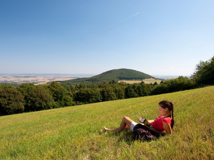
… four mountains in a circular route - idyllic valleys, quiet forests, and fantastic distant views. As a treat, there are rocks, gorges, caves, mighty tree giants, even an ant trail with its own bridge!
Highlights on the Traumpfad
- Volcanoes Gänsehals, Schmitzkopf, Sulzbusch, and Hochstein with fantastic views over the Vulkaneifel, Pellenz, and the Neuwieder Basin
- Idyllic Kellbach valley
- Massive tuff stone walls of the rock area "Rauhbuur"
- Impressive rock gorges of the Marxe-Lay
- Erlenbrunnen and the legendary Genoveva Cave
Impressions
General information
Directions
The access path at the Erlenmühle parking lot in Mendig leads into the idyllic Kellbach valley. After 700 m, the Four Mountains route begins uphill through the hillside. Soon, a detour to the rock area "Rauhbuur" with massive tuff stone walls is recommended; the stones were long used for baking oven construction. After the Schweinsgraben parking lot at the L 82, the route continues over rustic forest paths. The second small bridge in the forest deserves attention as it protects the ant trail crossing here! Further uphill, an excursion to the impressive rock gorges of Marxe-Lay is recommended. Shortly afterward, the path goes through beautiful mixed forest. Just before the forest edge at the sharp left turn, do not miss the A-oak! Then the ascent to the first mountain, the Gänsehals, follows; first views to the Laacher See and the Neuwieder Basin provide a breathing pause. A dreamy hollow way runs uphill and then further below the second mountain, the Schmitzkopf, with panoramic views. Once back in the forest, it goes uphill on soft paths to mountain number 3: Sulzbusch. The descent first leads through forests, then through fields and meadows, and after crossing the L 82, it passes refuge caves – the Sandhöhlen. The ascent to the fourth mountain, the Hochstein, requires some stamina. At the top, it goes through the forest to the lookout rock of the Hochstein. A few meters below awaits the next attraction: the Genoveva Cave. After descending through quiet forest into the Kellbach valley, the Sauer spring of the Erlenbrunnen at the starting point refreshes you.
Safety Guidelines
Surefootedness is required in some sections.
General safety instructions:
Safety instructions - Safe hiking on the Traumpfade
Hikers desire narrow paths, natural trails (over forest floor, grass paths, or along streams), and rocky ascents leading to spectacular views. It is self-evident that such paths must be walked with particular attention.
What to consider on your hike:
- Wear weather-appropriate, practical clothing that protects you from cold and moisture or heat and sun.
- Plan your hike with appropriate breaks and conserve your energy.
- Bring sufficient liquids. Refreshment options are not available everywhere.
- Please wear hiking shoes appropriate for the Traumpfade, which provide adequate support even on slippery and steep or rocky and uneven paths.
- If you believe certain route sections are not passable for you, you should detour or turn back. Especially in adverse weather, natural paths may have muddy and slippery sections.
- Especially in autumn, note that fallen leaves can conceal unevenness, roots, stones, or holes on the path.
- You should expect such path impairments when hiking.
- Before your hike, check online at https://www.traumpfade.info/traumpfade/wege-status/ to see if the Traumpfad you want to hike is closed, if detours are in place, or if construction work or other disturbances such as logging are planned.
- Recommended hiking months: April to October.
Difficulty classification
Easy routes
… have only slight altitude differences and are usually doable within half a day in terms of distance. They do not pose special demands on fitness or surefootedness. There are no sections requiring freedom from dizziness. Shorter steeper sections are possible. Depending on the path format, some parts can be difficult to walk in wet weather.
Medium routes
… are manageable with normal fitness. Path-like sections may require good surefootedness, so sturdy footwear is important; hiking sticks can be useful. Some somewhat longer and steeper ascents and descents are possible. Difficult (partly secured) sections are the absolute exception and can usually be avoided by detours. Natural sections can be difficult to walk in wet weather.
Hard routes
… demand very good fitness and endurance due to length and/or altitude meters. Very good surefootedness is also necessary to manage steep ascents and descents on partly demanding paths. Secured rope sections and/or simple climbing passages requiring a minimum level of freedom from dizziness are possible. Sturdy footwear and hiking sticks are important. Paths and exposed sections are often difficult or impossible to walk in wet or wintery weather.
Equipment
Sturdy footwear is recommended for the route!
Trail closures can be found at: https://www.traumpfade.info/traumpfade/wege-status/
Tip
For safety reasons, the operator of the Gänsehalsturm closes the tower from the start of the frost period until Easter. Due to condensation, ice can form and visitors could slip on the smooth steps and injure themselves.
Getting there
A 61 exit Mendig/Maria Laach – follow B262 direction Mayen – right towards Mendig/Bell/Obermendig – 200 meters left into Laacher Straße – 1st right 300 m to Erlenmühle parking lot (700 m to the start)
56743 Mendig, Erlenmühle parking lot (Ernteweg)
Parking
56743 Mendig, Erlenmühle parking lot (Ernteweg)
56745 Bell, Gänsehals, hiking car park Gänsehals
56745 Bell, Schweinsgraben parking lot at L 82
Public transit
Destination stop: Ettringen, Roderhöfe (lateral entry Hochsteinhöhle)
Line 390 RegioBus: Mayen - St. Johann - Bell - Niedermendig
Destination stop: Bell, Neustraße (approx. 1.5 km to starting point)
Line 390 RegioBus: Mayen - St. Johann - Bell - Niedermendig
Literature
- Traumpfade & Traumpfädchen Volume 2: The 19 best premium circular hikes in the Vordereifel, Ulrike Poller & Wolfgang Todt ISBN: 978-3-934342-61-3
- 27 premium circular trails Traumpfade, 10 years Traumpfade anniversary edition, Ulrike Poller & Wolfgang Todt, ISBN: 978-3-942779-43-2
Additional Information
Tourist Info Maria Laach, Tel.: 02636/19433, info@vulkanregion-laacher-see.de, www.vulkanregion-laacher-see.de
Traumpfade project office, Tel.: 0261/108419, info@traumpfade.info, www.traumpfade.info
Traumpfade app
Traumpfade app for iOS: Download app in iTunes
Traumpfade app for Android: Download app in Google Play
Pavings
- Crushed Rock (3%)
- Hiking Trail (3%)
- Unknown (94%)
Weather

This tour is presented by: Traumpfade im Rhein-Mosel-Eifel-Land, Author: Nicole Pfeifer


