The Stefan-Andres-Weg - hiking in the footsteps of the poet Stefan Andres from Schweich to Leiwen-Zummet
- start: Start: Schweich, Niederprümerhof; km: 0; elevation AMSL: 130 m
- destination: Destination: Leiwen, Zummet height; km 20.5; elevation: 250 m
- difficult
- 20,96 km
- 6 hours 11 minutes
- 534 m
- 430 m
- 124 m
- 80 / 100
- 80 / 100
The approximately 21 km long "Stefan-Andres-Weg" leading from Schweich to Leiwen-Zummet is one of the most diverse hiking trails in the region. It is intended to encourage experiencing the magnificent cultural landscape of the Moselle directly in the footsteps of the poet Stefan Andres.
Goethe already said: “Who wants to understand the poet, should go to the poet's land.”
The path is named after Stefan Andres, the Christian humanist and critical observer of his time, who spent his childhood between the endpoints of our hiking tour, the Moselle village of Schweich and the mill in the Dhron valley.
Several works, whose setting lies in the Moselle region, give the Stefan-Andres-Weg a geographical and literary thread.
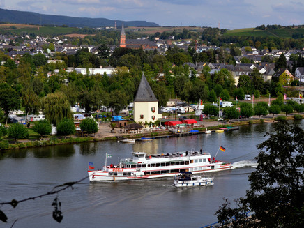
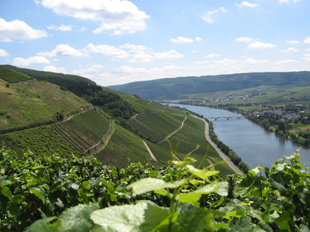
For this, the walker can experience the entire diversity of the Moselle cultural landscape from various viewpoints, which is mainly shaped by vineyards. Stefan Andres says in his book "The Great Wines of Germany":
“The mountains and hills on the Moselle ... have become somewhat animated by the river courses; they stand like ships, sometimes broadside, sometimes bow facing the river; sometimes they ... descend in steep terraces to the meadow shore, sometimes they swing beautifully curved for whole kilometers in pure southern slopes.”
Nothing needs to be added to this extremely vivid description by Andres.
With views of the vineyards between Schweich and Trittenheim, with immersing into the romance of quiet, shaded deciduous and mixed forests on the heights, the hiking trail combines a nature-near hiking experience with literary guided reflection on the cultural-historical development of the Moselle landscape.
Along the well-marked trail, numerous local inns, wine taverns and seasonal wine bars offer opportunities for refreshments.
Impressions
General information
Directions
The route mostly relates to notable points from the literary work and life path of Stefan Andres.
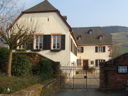
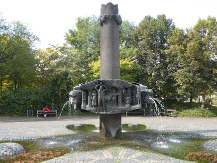
Thus, Schweich with the Stefan-Andres fountain and the Niederprümer Hof, which dedicates an exhibition to the work of the poet and simultaneously serves as the seat of the Stefan Andres society, is the starting point of the hiking trail.
The path can fundamentally be walked completely in a day’s route but is also excellently suited to be hiked in smaller segments.
It is marked with signs of the "Roman Wine Route", which include the characteristic book logo of the StAWW mainly in green, sometimes also red color.
The hike on the "StAWW" begins at Niederprümerhof in Schweich, the location of the Stefan Andres museum.
We leave the property via Hofgartenstrasse to the left, then continue along Mathenstrasse and follow Bergstrasse, which passes the cemetery and leads uphill through the motorway underpass towards the forest.
At the water tank, we take the steepest of the paths available there and continue uphill on the path running between forest and vineyards to the Rupperoth hut (km 2.5).
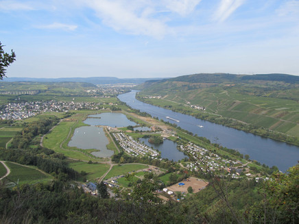
From here it flattens. We continue on the path between forest and vineyard, with constantly changing views of the Moselle. To avoid the Landwehr ditch, the path takes a detour through the forest and then opens a first gigantic panoramic view (km 3.5 / elevation 320 m AMSL) of the river valley, the Trier valley meadow, and the settled villages.
From here, the topographic high point of the left Moselle part of the StAWW, the path now leads gently but steadily downhill to Mehring. Initially still between forest on the left and vineyard on the right, later through the open landscape of “Wingerten”, meadows, and fallow land, always along the ridge with views of the Moselle and the villages of Longuich (with a Roman villa urbana), Longen and Riol (with the leisure area Triolago).
The village Mehring is reached in its new development area, extending around the Jewish cemetery (km 7.0). To pass through the village, one takes in succession the streets Panoramaweg, Moselblick, Kapellenweg, Linterstrasse, Bachstrasse (village center), Schulstrasse, and Neustrasse, finally reaching the Moselle bridge (km 8.5), over which the part of StAWW extending south (right) of the Moselle is reached.
At the opposite bridgehead, a natural 98-step staircase awaits, which takes us to the sports ground height of Mehring. Upon entering the bridge, we are briefly on the Moselle trail, which from the sports field is joined by the Moselle trail side trail Mehring Switzerland.
At the last houses, we leave these premium hiking trails and take the short path, which here again - passing the shooting house (km 9.5) - initially steeply ascending, then after a hairpin turn continuing flatter to the Kammerwald height (km 11.0 - approx. 50 m off-path to the right / elevation 320 m AMSL).
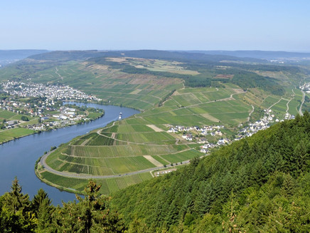
From here, a former Celtic refuge castle with a second gigantic view of the Moselle valley, one can not only look back at the part of the StAWW hiked so far with admiration but also - directly below - experience the point where the Moselle begins its characteristic meander course.
From the "Kammerknüppchen" viewpoint (as the rock nose around the summit cross is called locally) we go back to our broad forest path, continue uphill, leave a motorway overpass to the right, briefly cross the MTB trail park area, and after a short stretch along the motorway reach the jump ramp for paragliders (km 13.0), from which one can first see far along the further course of the Moselle, including the Moselle island with the dam and lock at Detzem.
Continuing we soon cross the connecting road (km 13.5) between Mehring and the motorway junction Mehring height, from where the Moselle trail and its side trail Mehring Switzerland accompany us to the absolute topographic and experiential high point, the 5-Lakes-View observation tower (km 15.0 / elevation 440 m AMSL).
One should definitely climb the 20 m high platform here to enjoy another magnificent view of the Moselle valley and far into the Eifel, which under appropriate air clarity also reveals its volcanic cones.
Back on the ground, we take on the continuation and last part of the StAWW, pass the Detzem grill hut, reach a crossroads after about 500 m, which we cross slightly shifted to the right straight ahead, then after another approx. 300 m turn left and from here gently downhill - including a short left/right path kink - continue straight for a long stretch to the holiday village Sonnenberg / Leiwen (km 18.5).
Immediately before the entrance we keep right, follow the paved road for about 200 m, then turn right again into the "home stretch" towards Zummet. After 2 km of gentle downhill path, we finally reach the most magnificent of all Moselle views and arrive here, above the 180-degree Moselle loop between Leiwen and Trittenheim, the center of the Stefan-Andres region, at the destination (pk).
Lowest point: Mehring, bridge; km 8.5; elevation: 120 m
Highest point: Five-Lakes-View; km 15.0; elevation: 440 m
Equipment
Sturdy footwear recommended.
Getting there
You can reach the town of Schweich very well via the motorways A1 or A 602. Take the motorway exit Schweich or Longuich and then follow the L 141 to Schweich. Niederprümer Hof is signposted.
Parking
Parking is available at Niederprümer Hof or at the nearby cemetery grounds.
Public transit
By bus line 220 from Trier via Ruwer, Schweich, Mehring, Leiwen, Trittenheim to Neumagen.
Further information about the detailed timetable at: https://www.vrt-info.de/
or directly on the timetable page of the VRT and enter bus line 220 in the mask: https://www.vrt-info.de/fahrplanauskunft/XSLT_SELTT_REQUEST?itdLPxx_page=ttb&itdLPxx_contractor=vrt&language=de
Maps
Hiking Map 1 : 25 000 Holiday Region Schweich on the Roman Wine Route
ISBN: 978-3-944620-13-8.
Schweich (Moselle).
With the new MOSEL hiking map "Holiday Region Schweich on the Roman Wine Route", the Eifelverein supplements its series of hiking maps on the Moselle with now the fourth hiking map at a scale of 1 : 25 000. This series of hiking maps, which the Eifelverein publishes in cooperation with Mosellandtouristik and the tourist information offices of the affected municipalities, will complete the Eifelverein’s map series after completion of all MOSEL hiking maps with the Moselle run in the southeast.
The basis for this detailed hiking map is the Official Topographic Map 1 : 25 000 of the State Office for Surveying and Geobasis Information Rhineland-Palatinate. The map uniformly costs 7.90 EUR and is available at the Tourist Information Roman Wine Route, Brückenstraße 46, 54338 Schweich, at Mosellandtouristik, and in bookstores as well as, of course, also at the Eifelverein e.V., Stürtzstraße 2 - 6 in 52349 Düren.
There the map can also be ordered online around the clock via the internet at www.eifelverein.de . ISBN: 978-3-944620-13-8.
Additional Information
Tourist Information Roman Wine Route
Brückenstr. 46
54338 Schweich
Tel: +49 (0) 6502-9338-0
Fax +49 (0) 6502-9338-15
info@roemische-weinstrasse.de
www.roemische-weinstrasse.de
Opening Hours
05/01 - 10/31
Monday - Friday:
09:00 am - 12:30 pm and
1:00 pm - 6:00 pm
Saturday:
09:00 am - 12:00 pm
11/01 - 04/30
Monday - Friday:
09:00 am - 12:30 pm and
1:00 pm - 5:00 pm
Pavings
- Asphalt Coating (10%)
- Crushed Rock (27%)
- Hiking Trail (57%)
- Path (4%)
- Street (1%)
Weather
This tour is presented by: Verein Römische Weinstraße e.V., Author: Jochen Conrad
