Moselsteig Stage 07: Mehring – Leiwen
- start: Mehring: Mosel bridge (Brückenstraße)
- destination: Leiwen: Intersection Mühlenstraße/Euchariusstraße
- medium
- 14,50 km
- 4 hours 10 minutes
- 570 m
- 425 m
- 120 m
- 60 / 100
- 40 / 100
To forests and panoramic views.
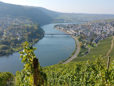
This demanding stage leads through the forests of Mehringer Schweiz and offers some exciting ascents and descents. It goes on steep paths through fir and spruce forests, through a beech high forest, and a flat summit forest. On the first fifth of the route, there is the opportunity for a detour to the leisure lake Triolago. Further along the route, as a special highlight, there is a 20-meter-high wooden lookout tower from which an extraordinary “five-lake view” can be enjoyed. Then it goes steeply downhill to Leiwen, the idyllic wine village located on one of the most beautiful Moselle bends between Trier and Bernkastel-Kues.
Impressions
General information
Directions
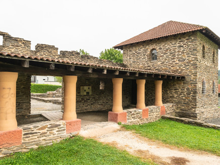
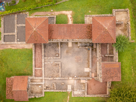
Across the Mosel bridge at Mehring, the Moselsteig – after starting in Perl – leads for the second time into the Hunsrück. You start this stage at the bridge. Directly at the bridgehead, you leave the street and climb steeply upwards on a staircase to the edge of the slope. From there, you will enjoy attractive views of Mehring, which is now located somewhat lower than the trail. The Moselsteig is now accompanied by the Moselsteig detour Mehringer Schweiz. At the sports field, a side path branches off to the Roman Villa Mehring – here you can experience history up close! Discover the Roman Villa Mehring with its large bath complex in its original appearance. Download the free ARGO app for this and activate an augmented reality application on your smartphone or tablet, which shows you the original building as if it still stood unchanged in its place. The free app and further information about the Roman Villa Mehring can be found at www.ar-route.eu.
The route leads to the forest edge and then a short stretch steeply uphill before going steeply downhill on a forest path almost to Mosel level. You then walk along a flat meadow path at the foot of the slope to the edge of the Triolago leisure complex. From here, a branch leads to Riol and the lakes. There is also an exciting opportunity to ride a summer toboggan run! And that very close to the Moselsteig.
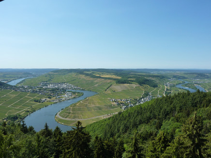
The next section up to the summit cross at Kumer Knüppchen requires not only good fitness but also a good deal of sure-footedness. Suitable footwear is absolutely necessary. Initially, it goes very steeply uphill directly along the Molesbach. But even after leaving the stream bed, the Moselsteig continues steeply uphill over stairs and past impressive slate rock formations to the summit cross. Here you can rest and let your gaze wander over the Moselle valley and the places upstream – Mehring, Riol, Longen, Longuich, and Schweich are closest. Especially the view of the stage 6 route from Schweich to Mehring over the Mehringer Berg is wonderful.
The next section is also demanding. It goes over stairs and natural rock steps briefly steeply downhill, then flat along the edge of the slope. A longer section through the forest follows, which steadily climbs and after a coniferous forest passage reaches an open beech high forest. In it, you then walk on a path to cross the K 85. Behind the street, you walk briefly along the forest edge and then on a path into the forest. The thick beech trunks here stand so far apart that the view can penetrate deep into the forest. The following ascending forest path leads to the Aussichtsturm Fünf-Seen-Blick (Five-Lakes View lookout tower). In good weather, you should definitely climb up! The view offers not only the announced “Five Lakes” but also considerable stretches of the stages already walked and still to come on the Moselsteig. Looking north, many domes of the Vulkaneifel can be seen in the distance.
The rest of this day’s stage leads only downhill or stays at height. After a section through the forest, the Moselsteig reaches the forest edge. Along a meadow with apple trees, it continues downhill. After another forest section, you come to a wayside shrine at the edge of the slope. Ahead of you lies an unusually straight stretch of the Moselle for the Middle Moselle. Upstream you see Pölich; downstream, several places are visible: Schleich and Ensch on the left side and Detzem and Thörnich on the right are the nearest villages. Further on, the Moselsteig leads almost at height on a field path between the forest edge and fallow vineyard areas. Again and again you get views towards the Moselle. At the end of this path, a rest area awaits you at Hinkellay under a solitary oak – a nice spot for a picnic! From here, the view stretches over a true sea of vines. And embedded in it is the stage destination Leiwen, one of the largest wine-growing communities on the Middle Moselle. Through the vineyards, the Moselsteig then initially leads steeply downhill, then with a still noticeable slope towards the Schantelbachtal. At the tennis courts, the access path branches off towards the center of Leiwen. It initially runs along the stream and then into the town. After 1 km you reach the stage end point at the bus stop on Euchariusstraße.
Equipment
- sturdy footwear
- weather-appropriate, functional hiking clothing
- packed lunch
Tip
The stage can also be tackled a little later in warm weather. The ascent is mostly in the cool forest.
Getting there
Start point: Mehring A 1, access points Mehring, Longuich or Schweich, then via B 53
End point: Leiwen A1, AS Föhren/Bekond and then L 48 or B 53 and L 48
Parking
Mehring: parking available along Moselstraße parallel to the B 53 or at Peter-Schröder-Platz (0.3 km access path)
Leiwen: small parking lot directly at Euchariusstraße bus stop; more parking is available at the Platz in Schulstraße
Public transit
You can reach the stage towns Mehring (bridge stop) and Leiwen (Euchariusstraße stop) by bus line 220.
There are regular connections. Please note that during the school holidays of Rhineland-Palatinate / Saarland, at weekends and on public holidays, there may be restrictions in the frequency! Please check the current daily timetables on the website of the Verkehrsverbund Region Trier (VRT):
Literature
"Moselsteig" - Official Moselsteig hiking guide by ideemedia, 14.95 €
Authors: Ulrike Poller, Wolfgang Todt, Publisher: ideemedia, 300 pages with almost 300 pictures, altitude profiles, QR codes, and GPS tracks, size 11.5 x 23 cm, ISBN: 978-3-942779-21-0, 14.95 €
"Official Moselsteig hiking maps" in pocket format:
The entire route is divided into 3 maps:
Leisure map Moselsteig - Map 1: Perl - Trier (Stages 1 - 4), ISBN: 978-3-89637-419-6
Leisure map Moselsteig - Map 2: Trier - Zell (Mosel) (Stages 5 -14), ISBN: 978-3-89637-420-2
Leisure map Moselsteig - Map 3: Zell (Mosel) - Koblenz (Stages 15 - 24), ISBN: 978-3-89637-421-9
Single map: 5.90 €
Maps in a 3-set: 14.50 € (ISBN: 978-3-89637422-6)
"Premium set"
Premium set, consisting of the official hiking guide including a 3-set of hiking maps, Publisher: ideemedia, ISBN: 978-3-942779-24-1, 26.95 €
The hiking guides and maps are available in bookstores or on the website https://www.visitmosel.de/wandern/service-infos-tipps under the section "Brochure order".
Maps
Leisure map Moselsteig - Map 2: Trier - Zell (Mosel) (Stages 5 -14), ISBN: 978-3-89637-420-2
Additional Information
Mosellandtouristik GmbH
Kordelweg 1, 54470 Bernkastel-Kues; Phone: +49 (0)6531/97330
Tourist information Roman Wine Route
Brückenstraße 46, 54338 Schweich; Phone: +49 (0)6502/9338-0
Weather

This tour is presented by: Mosel. Faszination Urlaub, Author: Mosellandtouristik GmbH
