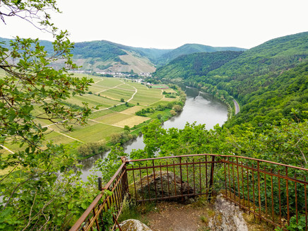
Moselsteig Detour Briedeler Schweiz
- start: Briedel, Balduinsplatz
- destination: Briedel, Balduinsplatz
- medium
- 10,46 km
- 4 hours 30 minutes
- 350 m
- 390 m
- 100 m
- 80 / 100
- 40 / 100
Exciting ascent, spectacular views, and relaxed descent.
An impressive hike through fields and forests, past rock formations and wonderful views. From Briedel, the path leads through the forest to the first viewpoint, the Hindenburglay. It continues uphill past interesting slate rocks until finally the saddle is reached, from where you should definitely take a detour to Beinter Kopf, which offers a fantastic view over Zell (Mosel) and the remains of a Roman mountain sanctuary. Here, various resting opportunities with a wonderful panorama provide the chance for an extensive break. Afterwards, it continues more leisurely, with views of Zell (Mosel), Briedel, Marienburg, and Bullay before the descent begins, which leads back to the starting point Briedel.
Impressions
General information
Directions
The detour to the Briedeler Schweiz starts at Balduinsplatz and first leads into the village to the main street. Via Sündstraße, it goes steeply uphill below the church and cemetery along the edge of the village. After a hairpin turn, you reach the edge of the forest and the beginning of the Way of the Cross. In the forest, the narrow path leads steeply uphill, accompanied by several Way of the Cross stations. Then the detour leaves the Way of the Cross and continues now not quite as steeply through the forest slope. Soon you will reach the first viewpoint, the Hindenburglay. Here, not only does the beautiful view from the protruding rock into the Moselle valley invite you to linger, but the delicately designed pavilion is also wonderful for a short rest.
The ascent is not yet quite done. Initially, the route takes you down a path slightly downhill and then without major elevation changes through the forest-covered slope. Interesting slate rocks on the left and right of the path catch the eye. After a last steep stretch uphill, you reach a saddle. From here, a detour leads to Beinter Kopf. The flat path over the ridge is quickly done. An information board informs you about the history of this place, where a Roman mountain sanctuary once stood. Rest areas, benches, and a shelter offer the opportunity for a refreshing break. You should definitely go to the rock pulpit because the view of the Moselle and Zell is one of the most beautiful on the river!
After the return to the saddle, the second part of the ascent awaits. The path leads windingly and steeply up the ridge. Walking among the rocks, it is not hard to understand how the name of this Moselsteig detour – namely Briedeler Schweiz – came about. At the end of the uphill section, the path ends and becomes a way to the "Schöne Aussicht" (Beautiful View) – and that is breathtaking! From here, at almost 400 meters in height, you not only look into the Moselle valley; rather, a panorama extends far into the Eifel region (in good weather as far as the Nürburgring). The open shelter and other resting options allow another breather. Now you have completed the ascent and almost half of the path. A 0.4 km access path can take you to the Bummkopf parking lot, which is also suitable as a starting point for the circular route.
Relaxed, the route continues on a flat forest path to the Wilhelmshöhe viewpoint. Here you are exactly right if you prefer a sunny spot during your break. The view of the Zeller district of Barl on the plateau opposite is already impressive. If you let your gaze wander along the Moselle to the left, you can see Briedel deep below and further away on the other Moselle side, high up, the Marienburg. Your location here is so high that you can look over the Marienburg saddle to Bullay and the further course of the Moselle towards St. Aldegund. A few minutes further through the forest is the Sündhaus, a small chapel that lies very idyllically here and represents the end point of the Way of the Cross, which the detour accompanied for a short section at the beginning.
The path leads to the nearby street, but immediately leaves it again and then follows the forest edge, which repeatedly offers views of the Hunsrück plateau. The descent begins on a well-developed forest road. Initially, you follow a small stream valley and then switch to a slope path that descends steeply to a rest area on the village edge of Briedel. Via the Kaiserlay (rest area with hut), you reach the point known from the outbound route at the Way of the Cross. From here, it goes steeply downhill into the village and back to the starting point Balduinsplatz.
Getting there
B 53 between Zell (Mosel) and Traben-Trarbach
Parking
Parking options along Moselstraße, directly adjacent to the starting point Balduinsplatz
Other starting points: P Bummkopf and P Sündhaus (both on K 52)
Public transit
Bus line 720 (Bullay – Traben-Trarbach), stop Briedel B 53 (from the stop it is only a few meters along Moselstraße to the starting point at Balduinsplatz). Further information at: www.vrminfo.de.
Literature
"Seitensprünge Band 2" - 17 premium circular hikes from Bernkastel-Kues to Koblenz by ideemedia
Authors: Ulrike Poller, Wolfgang Todt, Publisher: ideemedia, 160 pages, format: 11.0 x 16.4 cm, ISBN: 978-3-942779-60-9, €12.95
Maps
Recreational map Moselsteig - Map 2: Trier - Zell (Mosel) (Stages 5-14), ISBN: 978-3-89637-420-2
Hiking map "Zeller Land" ISBN: 978-3-944620-12-1
Additional Information
Mosellandtouristik GmbH
Kordelweg 1, 54470 Bernkastel-Kues; Phone: 06531/97330
Zeller Land Tourismus GmbH, Tourist Information
Balduinstraße 44, 56856 Zell (Mosel); 06542/96220
Pavings
- Asphalt Coating (10%)
- Path (27%)
- Hiking Trail (63%)
Weather

This tour is presented by: Zeller Land Tourismus GmbH, Author: Mosellandtouristik GmbH


