Moselle Trail Detour Klüsserath Legend Trail
- start: Portal at the car park at the Klüsserath weather station
- destination: Portal at the car park at the Klüsserath weather station
- medium
- 11,90 km
- 4 hours
- 290 m
- 310 m
- 145 m
- 80 / 100
- 40 / 100
Legendary hiking between spooks and fright.
A variety of legendary stations can be found along this premium hiking trail - which leads over 11.9 km through a varied and typical Moselle wine and cultural landscape. For example, you can enjoy a very nice view of the Rudemsberg. There, the "Rudemsmännchen" is said to still spread spooks and fright today because many years ago, through a false oath, it ended a border dispute in its favor. Between Trittenheim and Klüsserath, the path passes the "Eselstrapp", also called "Hinkelstein", with a magnificent view of the Moselle valley. According to legend, a maiden riding a mule saved herself by jumping into the valley ahead of her pursuer. And the footprint of the mule is still visible on a large (Hinkel) stone, a Celtic menhir.
The eponymous wine town Klüsserath with its culturally and historically significant townscape and a broad range of gastronomic offers is reachable via access paths.
Impressions
General information
Directions
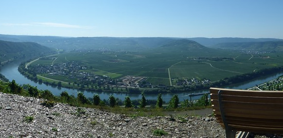
Starting point for the Klüsserath legend trail detour is the portal at the car park by the weather station. Regardless of how the portal with the bench and the information board about the legend of the crusader was reached (by car or via the approx. 2.5 km access path through the vineyards), you should let the panorama here sink in a little before you start. The entire Moselle loop of Klüsserath can be overlooked. A sea of vineyards, countless wine towns lined up along the blue ribbon of the Moselle. A magnificent start to a varied circular route.
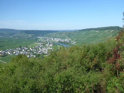
The route leads on the first stretch very relaxed and level along the edge of the forest and vineyards. At the paragliders' starting place (another great view), the detour then changes to a steep forest path, which winds shortly and sharply uphill to the open plateau. Then briefly downhill and half around an orchard. Past old fruit trees, it then goes further downhill into the vineyards. Initially only on one side, but then the path is flanked by vines on both sides. Back at the edge of the slope, the Klüsserath legend trail runs level along the edge. Unfortunately, the view of the Moselle is blocked by a strip of hedges and bushes. All the more impressive and surprising is the view from the soon-to-be-reached "Hinkelstein." The panorama includes the entire Moselle valley between Pölich and Trittenheim. Rest area and bench invite you to "watch TV." The "Hinkelstein" is an approximately 3,500-year-old menhir from the Neolithic period. The legend of the Eselstrapp (Donkey's Trail) surrounds the stone (more on the information board).
Continuing downhill through vineyards. From a meadow you can catch a glimpse of a small piece of the Moselle. The detour has changed sides over the ridge. The view now falls on the vineyards of Neumagen. The Moselle needs about 7 river kilometers for this, the hiking trail not even 500 meters. Steeply downhill the legend trail reaches a primeval side valley. The zigzag path here leads through an old vineyard area, recognizable by the still existing vineyard posts. After a short ascent, a stream is crossed, then the path approaches the Moselle valley further downhill. Through vineyards, one reaches shortly before the forest the viewpoint to the Martyr's Chapel. The bench is ideally placed here to enjoy the view of the chapel on the other side of the Moselle.
Through the shady forest, the detour now leads uphill for the next almost 2 km. Not steep, but noticeable. Through the trees on the steep slope, small glimpses are sometimes possible, but the view of Neumagen on the other side of the Moselle is really great first at the "little tower," which is reached via a path at the end of the climb. This is a barbecue and shelter hut with resting places. Perfectly suitable for a stop after the effort.
The path continues now. It leads steeply downhill through the oak forest, accompanied by moss-covered slate rocks. Over a soft forest path it goes moderately downhill into the quiet Moselle side valley. Upon reaching the brook, the detour then reaches the lowest point of the entire circular route. The Moselle Trail is only 100 m away here and via the same access path you can reach Neumagen (gastronomy & accommodation) from here. At the same time, half of the route distance is accomplished here.
The path leads steeply uphill into the gorge valley, quickly gaining height. After a cross path is reached, the slope becomes flatter. However, it continues uphill on the slope. The gorge valley becomes narrower and partly somewhat gorge-like. At the height, the Klüsserath legend trail then meets a large field. The ascent is almost done here. The bench at the upper forest edge offers walkers a view over the plateau to the Hunsrück. In addition, you can read the legend of the money pit on the information board here. At a large forest intersection, the highest point of the detour is reached. Until the Klüsserath grill hut, it continues on a flat forest road. Here there are also ideal rest places for a break on hot days.
Without major altitude differences, it continues through the forest. The trail markings indicate that you are on an old pilgrim path here. Parallel to a water ditch, the path leads downhill to a well and further resting places. Then the path reaches the vineyards again. Surrounded by vines, the detour first passes a bench, then steeply downhill to a bench. Again with fantastic view. You look at the mouth of the Eifel creek Salm into the Moselle. Here a short steep access path branches off to the car park at the Klüsserath church. The information board reports about the legend of the Rudemsmännchen.
The vineyard path now leads through the Klüsserath Brotherhood vineyard site. The vineyards fall so steeply to the Moselle that the entire route offers a great view of the vineyard landscape. The houses of Klüsserath seem only a stone's throw away but lie deep down in the valley. A steep serpentine path brings you to the path along the edge of the slope. You then follow this comfortably without altitude difference to the starting point at the Klüsserath weather station.
Even if you already know it from the outward journey, the panorama here is simply great!
Tip
Neumagen is also a very good starting point for the circular path. From here, a short access path leads over the Moselle bridge to the Klüsserath legend trail detour. The advantage of this starting point: the access path meets the detour at the lowest point, i.e. no additional altitude difference on the access path.
On "flight weather" you should plan time to watch the paragliders. The starting point is very close to the entry portal. Sometimes several dozen paragliders can be watched at the same time.
Getting there
B 53 between Schweich and Bernkastel. The Klüsserath weather station is accessible via paved vineyard paths.
Parking
Car park directly at the start-finish point.
Car park at the Klüsserath church. From here, an approx. 1 km and an approx. 2.7 km access path leads to the detour.
Public transit
Klüsserath is accessible by line 333.
Literature
"Seitensprünge Band 1" - 10 premium circular hikes from Trier to Bernkastel-Kues by ideemedia
Authors: Ulrike Poller, Wolfgang Todt, Publisher: ideemedia, 114 pages, format: 11.0 x 16.4 cm, ISBN: 978-3-942779-59-3, €12.95
Maps
Moselle Trail Leisure Map - Map 2: Trier - Zell (Moselle) (stages 5 -14), ISBN: 978-3-89637-420-2
Additional Information
Mosellandtouristik GmbH
Kordelweg 1, 54470 Bernkastel-Kues; Telephone: 06531/97330
Tourist Information Roman Wine Road
Brückenstr. 46, 54338 Schweich; Telephone: 06502/933812
Pavings
- Crushed Rock (12%)
- Path (12%)
- Hiking Trail (75%)
- Asphalt Coating (1%)
Weather

This tour is presented by: Verein Römische Weinstraße e.V., Author: Mosellandtouristik GmbH


