Masdascher Burgherrenweg route
- start: Mastershausen, bus stop town center
- destination: Mastershausen, bus stop town center
- medium
- 13,88 km
- 5 hours
- 306 m
- 461 m
- 257 m
- 80 / 100
- 60 / 100
A route to enjoy solitude and silence in untouched nature. Along the way, we experience secluded valleys, deep adits, rugged slate cliffs, and ancient buildings from the Celtic, Roman, and knightly eras. Magnificent distant views and dreamy panoramic views from the heights, mill stories in the valleys, and an extraordinary castle ruin with massive walls.
The route is designed to enjoy silence in untouched nature. Along the way, you experience secluded valleys, deep adits, rugged slate cliffs, and old buildings from the Celtic, Roman, and knightly periods. On the heights, you enjoy magnificent distant views and dreamy panoramic views; relics of old mills quietly bear witness in the valleys. Along the way, you pass the Bucher Mill, Mohre Mill, Schweitzer Mill, and Kaspers Mill.
The storm Wiebke left enormous forest damage in the Mastershausen forest in 1990. The still visible windthrow was caused by storm Xynthia in 2010.
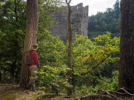
In the valley, the path leads to the rest area "Katzenloch." Suddenly, the huge ruin of Balduinseck castle with its massive walls rises into the sky. Then a long ascent to the castle hill. The striking rock outcrop was already used by the Celts. A steep serpentine descent leads past a former "Roman Well" downwards. At the rest area "Herzenauer Hannes," the path along the water ends. From here, a detour to the Geierlay suspension bridge is possible. On the further path, you come to the former Apollo ore mine. The development of the mine field began in 1891. Over forest and meadow paths, it goes to the Hunsrück plateau. Since 2008, the Galgen tower has stood here, which is supposed to recall a Roman watchtower. In old times, there was a gallows here. Not far from the tower stands the "Eich," dating from around 1500 AD.
The path was rated with 92 adventure points by the German Hiking Institute.
Impressions
General information
Directions
From the center of Mastershausen, distinctive orange-white access logos mark the way through the town to the start of the route not far from the barbecue hut. Here we switch from the access path to the route, leaving the barbecue hut and the Hallgarten recreational area on the right. After a gentle ascent with magnificent panoramic views, the path leads for the first time into the forest. We deeply breathe in the spicy scent of the conifers and reach at the edge of a windthrow (1) the first of 8 information boards.
With a clear view of the deeply incised valley of the Mastershausener stream, the route bends downhill and passes a sensory bench halfway down. In the valley, we cross two murmuring streams via a footbridge and arrive at "Am Katzenloch," where a cozy rest area awaits and an old adit mouth bears witness to slate mining. But just after the next curve, the water comes into focus. The path switches to the west bank and leads to long-ruined relics of ancient mills. First, we pass the Bucher Mill (information board 2), before the ruin of the Mohre Mill (information board 3) reminds of the once busy milling activity in this quiet valley.
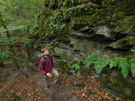
After crossing the stream again, we follow a delightful hiking section through almost untouched nature, where rugged slate cliffs and the quietly trickling stream compete for the hiker's attention under the shady canopy of leaves. But suddenly this contest is forgotten when the massive walls of Balduinseck Castle rise unexpectedly!
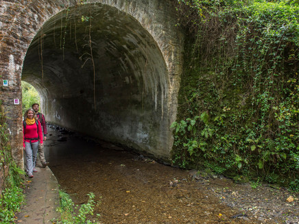
The recently restored castle from the 14th century was once a stronghold of the Archbishop of Trier against the Sponheimers settled in Kastellaun. A short detour to the castle does not require much imagination to bring the Middle Ages to life. Back on the route, it briefly goes underground as the hiking path crosses under the L 203 road together with the stream. On the other side, a floodplain forest enchants us before a footbridge helps us cross the stream. The following climb through the rough rocks demands surefootedness, but the next rest spot rewards the effort. Past the Kaspers Mill (information board 4), the path climbs, offering great views over the valleys and purposefully heads towards the next cultural highlight: the castle hill (information board 5)!
This striking rock outcrop was already used by the Celts. We can enjoy the unique atmosphere in a quirky shelter. And again, we hike downhill. Passing the "Roman Well" (information board 6), we reach the valley floor in serpentines, where further rock hollows testify to mining. At the Herzenauer Hannes rest area (information board 7), the ascent to the Apollo mine (information board 8) begins, where not slate but ores were mined. The following zigzag path gets strenuous, but finally, we have conquered the Hunsrück plateau, and the breathtaking panoramic view from the tower on the Galgenberg compensates us for all the effort. Just a few steps later, it gets spooky, but at the "Eich" (information board 9), no one is hung anymore.
The path gently descends and reaches the barbecue hut at the recreational area. From here, we return along the access path back to Mastershausen.
Safety Guidelines
The routes have some steep, difficult, and slippery sections in rainy or winter weather. Therefore, surefootedness and good fitness are essential prerequisites for hiking these premium circular routes.
Equipment
Sturdy footwear is required; a walking stick proves helpful.
Tip
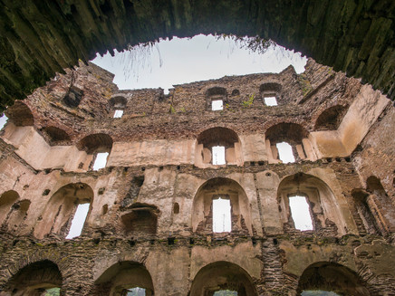
Ruine Balduinseck: The castle ruin was built as a state castle by the Archbishop of Trier, Balduin of Luxemburg, between 1325 and 1330. For its time, it is a massive and bulky structure. The rectangular four-story building measures a proud 22.70 m x 14.50 m. A luxurious spiral staircase for that era leads through all four floors in the northeast corner of the building, all equipped with large fireplaces. On the ground floor, a well with a shaft diameter of 1.50 m was installed, proving that it was designed for long-term defense. In 1675, Balduinseck was leased, and by 1711, it was reported as neglected. Since 1780, the ruin has decayed. Preparations to secure the castle ruin began in 2007, with the state and municipality putting in substantial effort to preserve it. Today, it is restored as far as possible under monument protection regulations.
Getting there
L 203, K 69 or K 64 to 56869 Mastershausen
Navigation: Johann-Steffen-Straße, 56869 Mastershausen
Parking
Mastershausen town center, bus stop "Dt. Eck"
(Navigation: 56869 Mastershausen, Johann-Steffen-Straße)
Parking at the community hall.
Further starting points:
Parking at Balduinseck Castle ruin (L 203)
Parking at the barbecue hut
Public transit
Kastellaun - Mastershausen (Balduinseck Castle Ruin)
Bus line 630, several times daily Monday-Friday, bus lines 615+630 (transfer Kastellaun) Saturday and Sunday, several times daily
Info at: www.vrminfo.de
Literature
Free:
Brochure "Experience Trails" with maps, elevation profiles, short descriptions, and dining tips for all 111 routes
and overview map - a light folding map with a rough location overview of all 111 routes
Information and requests at www.saar-hunsrueck-steig.de/prospekte
Paid travel guides and books in the shop at www.saar-hunsrueck-steig.de
Additional Information
Tourist Information Kastellaun, Marktstraße 16, 56288 Kastellaun
Tel. 06762 401873, www.kastellaun.de
Hunsrück Touristik GmbH, Building 663, 55483 Hahn Airport
Tel. 06543 507700, www.hunsruecktouristik.de
Weather
This tour is presented by: Hunsrück, Author: Iris Müller
